Show the ocean's layers as a labeled cross-section using the zone names and depth values you take from an approved source, as one teaching infographic.
One generated cross-section with your ocean zones stacked from the surface down, each labeled with the depth range you supply, plus a source line. It is an illustration and not to scale. Check every depth value and unit.
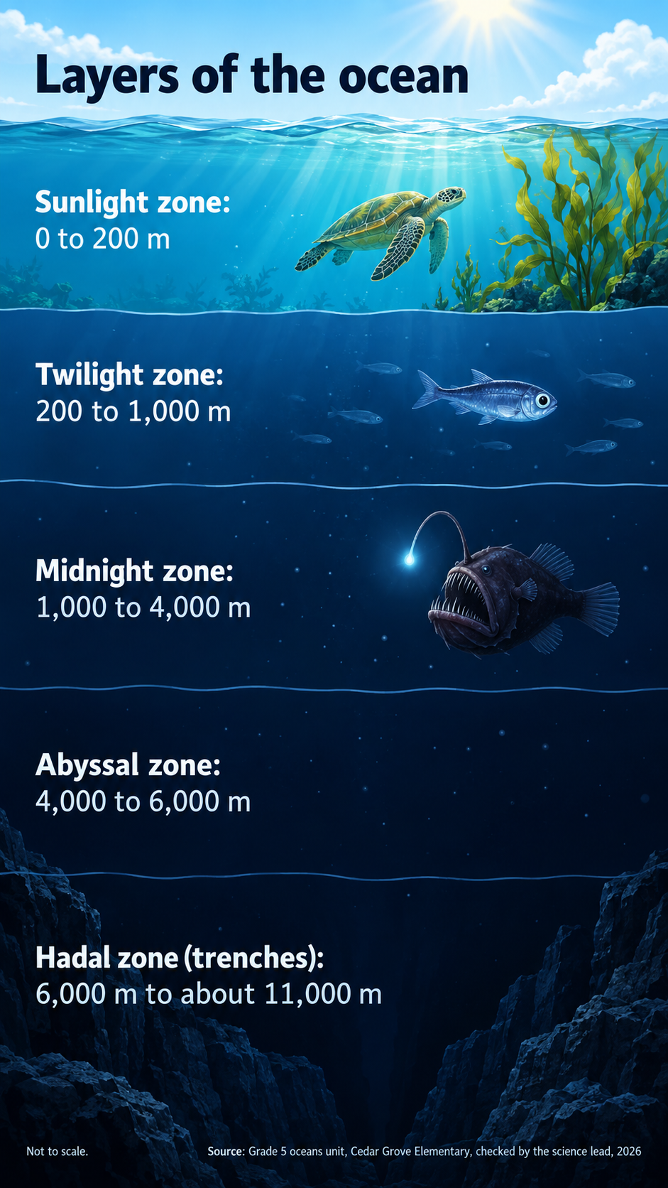
Five ocean zones in meters with creatures for a Grade 5 class
Title
Layers of the ocean
Zones and depth ranges, top to bottom
Sunlight zone: 0 to 200 m
Twilight zone: 200 to 1,000 m
Midnight zone: 1,000 to 4,000 m
Abyssal zone: 4,000 to 6,000 m
Hadal zone (trenches): 6,000 m to about 11,000 m
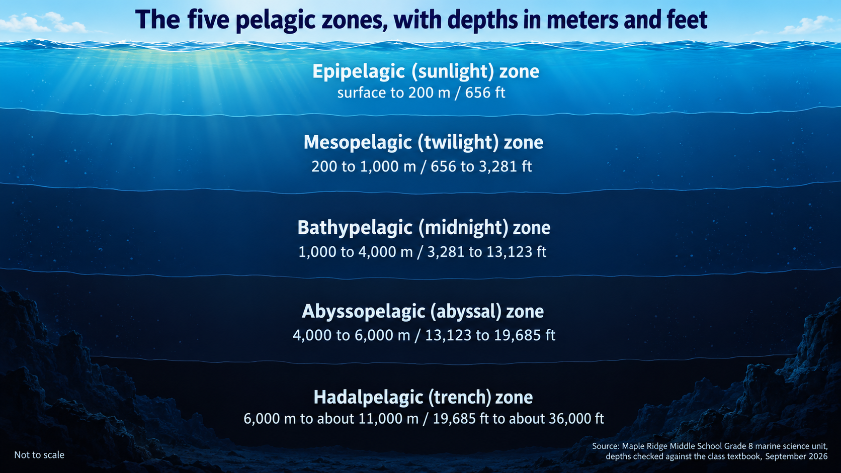
Scientific zone names in meters and feet, no creatures
Title
The five pelagic zones, with depths in meters and feet
Zones and depth ranges, top to bottom
Epipelagic (sunlight) zone: surface to 200 m / 656 ft
Mesopelagic (twilight) zone: 200 to 1,000 m / 656 to 3,281 ft
Bathypelagic (midnight) zone: 1,000 to 4,000 m / 3,281 to 13,123 ft
Abyssopelagic (abyssal) zone: 4,000 to 6,000 m / 13,123 to 19,685 ft
Hadalpelagic (trench) zone: 6,000 m to about 11,000 m / 19,685 ft to about 36,000 ft
Creatures or labels per zone (optional)
Left empty
Source and date
Maple Ridge Middle School Grade 8 marine science unit, depths checked against the class textbook, September 2026
Long scientific zone names with two units on every band and no creatures listed. Checks both units survive on each band, long names wrap without abbreviation, and no animals or landmarks are added to fill the deep zones.
Same task, three directions
Pick a direction to start from.
01
Classic cross-section
A side-on slice of the sea with the water darkening band by band down to a simple seabed and trench.
02
Depth ruler
A tall ruler runs down one side and marks only your depth values, with the zones as colored segments.
03
Submersible descent
A small generic submersible sinks along a dotted line, passing a label at each zone boundary.
What the template keeps
The parts that stay consistent.
01
Surface to seabed order
Zones always stack in the order you give, from the top of the water column down.
02
A range on every band
Each zone carries its own depth label, so readers take values from text rather than from the drawing.
03
Honest scale note
A small not-to-scale note reminds readers that band heights are illustrative.
How to use it
From details to a result.
01
Give it a title
A short heading for the image, such as Layers of the ocean.
02
List zones from the surface down
One zone per line with its depth range and unit, copied from your textbook or approved source.
03
Add creatures and the source
Optionally list creatures for some zones, then name the source and date for the depths.
04
Review, generate and check
The zones and source open in Vizify for a final look before sending. Check every depth and unit on the result against your source.
Output boundaries
What to check before you use it.
Band heights are illustrative and not to scale. Readers should take depths from the labels, not from the drawing.
Depth values, units and zone names are image text and can change. Check every number against your source.
Nothing is looked up. No record depths, trenches, animals or comparisons are added unless you supply them.
Up to six zones fit legibly. Measured depth data or a detailed profile belongs in a chart built from your numbers.
One image per request. Portrait and landscape are aspect-ratio directions, not fixed dimensions.
QuestionsWhere should the depth values come from?+
From your textbook, curriculum or another source you trust. Different sources round depths differently, so copy the values your class uses. The template does not fill any in.
Why does the image say it is not to scale?+
The deepest zones are thousands of meters thick, so a true-scale drawing would squash the sunlight zone into a thin line. Bands are sized for readability, and the labels carry the real values.
Can I add animals to each zone?+
Yes. List them per zone in the optional field, such as lanternfish in the twilight zone. Only the creatures you list are drawn.
Can I use feet instead of meters?+
Yes, or both. Write each range exactly as it should appear, and the units are kept as you typed them.